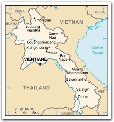

Laos :: Geography

|
Location: Southeastern Asia, northeast of Thailand, west of Vietnam
Area: 236,800 sq km
(land: 230,800 sq km; water: 6,000 sq km)
landlocked, it has no seacoast
Terrain: mostly rugged mountains; some plains and plateaus
Elevation extremes
lowest point: Mekong River 70 m
highest point: Phou Bia
Major river: The Mekong River
The Mekong River begins in Tibet and flows through China, Laos, Thailand, Cambodia and Vietnam. More of it flows through Laos than any other country. The Mekong forms part of the border with Thailand.Land use
The giant catfish, native to the Mekong River, is in danger of extinction due to overfishing, as well as decrease in water quality as a result of development and upstream damming. Fishing for the giant catfish is illegal in Laos, Thailand and Cambodia.
arable land: 4.01%;
permanent crops: 0.34%;
other: 95.65% (2005)
Irrigated land: 1,750 sq km (2003)
Natural resources: timber, hydropower, gypsum, tin, gold, gemstones
Climate: tropical monsoon; hot in the lowlands, cold in the mountains;
May to November: rainy season;
December to April: dry season
Natural hazards: floods, droughts, windstorms, epidemics (e.g., cholera, malaria)
Environment issues: (1) unexploded ordnance; (2) deforestation; (3) soil erosion; (4) most of the population does not have access to potable water